


When Christopher Columbus set out to find a route to Asia, he consulted the works of the most knowledgeable cartographers and scientists in recorded history at that time to determine the best, safest and most efficient route from his point of departure in Palos, Spain to the Eastern shores of the same land mass he departed.
Maps and Explorers’ Christine Sawyer traces his efforts to build a case for funding such a voyage; he had to obtain permission as well as the sponsorship for what would prove to be a very costly series of expeditions.
Crucial to his case, Sawyer writes, was his estimation of what was then known as the oecumene – the combined landmass of Europe, Asia and Africa.

Ptolemy, one of the earliest sources consulted, believed that this landmass stretched across 180 degrees of the planet’s surface.
Later cartographers would estimate 225 degrees of longitude, and despite a history of debate on the matter, Columbus believed that 225 degrees was an understatement, thus shortening even further the distance he would have to travel to reach the east coast from the west.

In reality, the oecumene spans less than 180 degrees of longitude, and so when Columbus sailed west and reached land, he quickly correlated the places that he found with his maps of the east coast of Asia despite having found the east coast of North America.
As the Encyclopaedia Britannica notes, Columbus would repeat this miscalculation on several successive voyages believing he was founding Spanish settlements throughout eastern Asia.

In recent years, researchers have begun to collect and study the maps that would have informed Columbus’ voyages in an effort to dig deeper into the explorer’s curious navigation. In particular, LiveScience’s Laura Geggel writes, researchers have returned to the oldest surviving maps from the period with new technology to extract more information from them than was previously available.

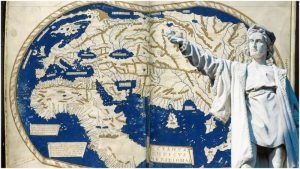
Using multispectral imaging, a team led by Chet Van Duzer of the University of Rochester’s Lazarus Project has scanned and analyzed a 1491 map of the world that Columbus would likely have consulted as he made his preparations.
Though the map has faded over the centuries, Geggel writes, the team was able to recover a significant amount of text and graphical information from it by scanning it with a variety of different wavelengths of light which are reflected or absorbed differently by the different inks and materials employed by the original cartographer.

The map, which was previously “an almost unstudiable object” according to Van Duzer, was created by the German cartographer Henricus Martellus very shortly before Columbus’ first expedition.
Martellus’ map was itself the result of secondary research and consultation of a variety of scientific texts including a popular and contemporary treatise on biology and the testimony of Africans during the Council of Florence.

The map shows the oecumene as taking up well over 75 percent of the longitude that it shows.
Columbus’ contention with smaller estimates of the oecumene’s size was his belief that earlier scientists were unaware of the size of its eastern reaches, but there is surprisingly little water between the edge of the continent and the edge of the map in Martellus’ depiction – it is missing the entirety of the American continents, as well as nearly everything in between these and the oecumene.

Still, the recently-revealed map was a feat for its day and age; it showed the correct orientation of Japan, which other maps did not, and likely influenced the next generation of maps that began to appear following Columbus’ misguided discoveries.
Read another story from us: The mystery of the Christopher Columbus letter stolen from Vatican
Van Duzer speculates that if Columbus didn’t see Martellus’ map, he likely saw a version of it – it was an influential depiction and among the best of the age. Thanks to the work Van Duzer’s team, we are now able to view it as Columbus did.