


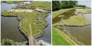
The World Map at Lake Klejtrup is a miniature 5,000-square-meter world map, built of soil, stones, and grass. It is located near the village of Klejtrup, Viborg Municipality, Denmark. Søren Poulsen, the creator of the World Map was born in Denmark in 1888. Having spent part of his life in America, he returned to the village where he was born, by the lake in Klejtrup.


In 1943, he was working on the drainage of the surrounding meadows. He found a stone shaped like Jutland, which inspired him to create a small world of his own. During the winter months, with the use of primitive tools, big stones were placed carefully on the ice – and when spring arrived they could easily be tilted into place, and slowly the World Map took shape.


The World Map was created between 1944 and 1969, and measures 45 by 90 meters (49 by 98 yards). One 111-kilometre (69 mi) degree of latitude corresponds to 27 centimeters (11 inches) on the map. Owing to the difficulties of spreading out our planet’s spherical shape, the Northern Hemisphere is marked in two places, thus ensuring a better impression of the correct distances between the countries. Red poles mark the equator, and each country is represented by a small flag planted proudly in the ground.


The outline of the map has remained unchanged since 1969, the year in which Poulsen died at the age of 81 and just a few months after completing the map. Today, the “World Map at Lake Klejtrup” is a popular attraction in the Viborg area.