


Stories about the island had circulated around Europe for centuries, telling that it was the Promised Land of the Saints, an earthly paradise where fairies and magicians lived. Hy-Brasil is a phantom island said to lie in the Atlantic Ocean west of Ireland. Irish myths described it as cloaked in mist except for one day every seven years, when it became visible but still could not be reached.

The etymology of the names Brasil and Hy-Brasil is unknown, but in Irish tradition, it is thought to come from the Irish Uí Breasail (meaning “descendants (i.e., clan) of Breasal”), one of the ancient clans of northeastern Ireland. cf. Old Irish: Í: island; bres: beauty, worth, great, mighty. Despite the similarity, the name of the country Brazil has no connection to the mythical islands. The South American country was at first named Ilha de Vera Cruz (Island of the True Cross) and later Terra de Santa Cruz (Land of the Holy Cross) by the Portuguese navigators who discovered the land. After some decades, it started to be called “Brazil” (Brasil, in Portuguese) due to the exploitation of native Brazilwood, at that time the only export of the land. In Portuguese, brazilwood is called pau-brasil, with the word brasil commonly given the etymology “red like an ember”, formed from Latin brasa (“ember”) and the suffix -il (from -iculum or -ilium).

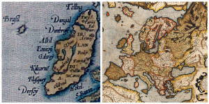
Angellino de Dalorto, a Genoese cartographer, was the first to map Brasil as early as 1325. He placed the island west of Ireland. On successive sailing charts, it appears southwest of Galway Bay. Later it appeared as Insula de Brasil in the Venetian map of Andrea Bianco (1436), attached to one of the larger islands of a group of islands in the Atlantic. This was identified for a time with the modern island of Terceira in the Azores.

A Catalan chart of about 1480 labels two islands “Illa de brasil”, one to the south-west of Ireland (where the mythical place was supposed to be) and one south of “Illa verde” or Greenland. On maps, the island was shown as being circular, often with a central strait or river running east-west across its diameter. Despite the failure of attempts to find it, this appeared regularly on maps lying south-west of Galway Bay until 1865, by which time it was called Brasil Rock.

In 1480, a fully-laden ship left the port of Bristol, England to sail west in search of the island of Hi-Brazil, which was believed to be somewhere off the coast of Ireland. It met with no success. Nor did the two ships which sailed the following year in search of the island fare any better. And the five ships captained by John Cabot which set sail in 1498 to search for Hi-Brazil came up equally empty-handed.

In 1674 a Captain John Nisbet claimed to have seen the island when on a journey from France to Ireland, stating that the island was inhabited by large black rabbits and a magician who lived alone in a stone castle, yet the character and the story were a literary invention by Irish author Richard Head. Roderick O’Flaherty in A Chorographical Description of West or H-Iar Connaught (1684) tells us “There is now living, Morogh O’Ley (Murrough Ó Laoí), who imagines he was personally on O’Brasil for two days and saw out of it the iles of Aran, Golamhead, Irrosbeghill, and other places of the west continent he was acquainted with.”

Hy-Brasil has also been identified with Porcupine Bank, a shoal in the Atlantic Ocean about 200 kilometres (120 mi) west of Ireland and discovered in 1862. As early as 1870 a paper was read to the Geological Society of Ireland suggesting this identification. The suggestion has since appeared more than once, e.g., in an 1883 edition of Notes and Queries and in various twentieth-century publications, one of the more recent being Graham Hancock’s book Underworld: The Mysterious Origins of Civilization.