


In the aftermath of hurricane sandy, which devastated the coastal regions of North America; lower Manhattan found itself submerged underwater for most parts. After water reclaimed the land, the new boundary of Manhattan matched the boundary that existed in the 17th century before it was systematically expanded in the wake of industrialization of the city.
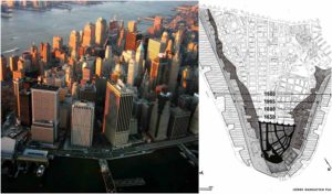
The landscape of Manhattan used to be very different from what it looks like today; it was very narrow lacking the manoeuvrability of modern urban habitat. The eastern waterfront of the island was marked by the curve of Pearl Street; named as such due to the abundance of shells on the shore. Moving towards the west the region met the Hudson River at the border of Greenwich Street.

The expansion project of Manhattan commenced in 1646, when the governor of New Amsterdam colony Peter Stuyvesant, approved to stretch the boundary of the island equally from all sides; initially, the expansion was a mere four block each side.
The series of reclamation did not stop with Peter Stuyvesant’s initiation; it rather went on for many years in various forms. However, the dramatic transformation of the celebrated island did not take place until the 20th century.
The first major expansion of started in 1934, and the construction of a highway as part of 9.5 miles on East River Drive, which is now known as FDR Drive. The bridge stretched from Lower Manhattan’s battery towards Triborough Bridge. The construction of the highway was an ambitious and challenging project; it was mostly built on landfills and solid relieving platforms supported by piles.

The next phase of the expansion came about in 1976, when the 1.2 cubic yards of rock and earth from the excavation sites of the World Trace Centres’ buildings, made the foundation of the an additional 24 acres of Battery Park City along the Hudson River. In the coming years the area became a metropolis of profound hustle and bustle with all the amenities of an urban habitat; close to the concrete ridden New York City while still sitting on the edge of Hudson River. However the romantic vicinity to the Hudson made the new housing projects and other amenities prone to regular flooding.
However, the elements really fought back with the true natural fervour with Sandy, when a vast majority of the reclaimed area got submerged under water. The residents of the lower

Manhattan and authorities woke up to the realization of the real vulnerability of the region only after Sandy; when human civilization was pushed back to its original boundaries that were there some 400 years ago. The overwhelming waves of the storm that hit Lower Manhattan in October 2012 restricted Manhattan back to its historic place i.e. between Pearl and Greenwich Street.

Around the time of the American War of Independence, the population of Manhattan had touched the 30,000 mark. This pushed the authorities to invite people to buy landfills beyond the waterfronts creating more accommodations for the growing population.