


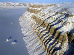
Geophysicists have discovered evidence of an ancient drainage network buried beneath Greenland’s ice sheet. At one point in time, this network extended across nearly a fifth of its total surface, they say, and experts found some of the channels within this system were about a mile deep and over seven miles wide.
This size is comparable to the Ohio River Basin. This drainage system even predates the formation of the ice sheet about 3.5 million years ago.
Why would an ancient drainage basin be important today? According to a new analysis gathered from ice-penetrating data, the ancient river network influences and radiates from the modern Jakobshavn Glacier. They mapped this dendritic network by using two different software tools.
Writing about their finds in Geophysical Research Letters, the team of researchers, who hail from both the University of Bristol and Imperial College London, explained, “The size of the drainage basin is ∼450,000 km and accounts for about 20% of the total land area of Greenland.”

They wrote. “Topographic and basin morphometric analyses of an isostatically uplifted (ice-free) bedrock topography suggests that this catchment predates ice sheet initiation and has likely been instrumental in controlling the location and form of the Jakobshavn ice stream, and ice flow from the deep interior to the margin, now and over several glacial cycles.”
Their findings can not only be used to determine what past river drainage looked like in Greenland, but also what river drainage might look like in the future as the ice sheets melts.
The team includes Michael Cooper, who comes from Bristol’s School of Geographical Sciences and Cabot Institute. Cooper and his colleagues studied the bedrock in Greenland using data collected mainly by NASA (through Operation Ice Bridge), as well as various researchers from the UK and Germany, over several decades.
The team collected the data by using aircraft with ice-penetrating radar, a particular radar that bounces off the bedrock, underneath the ice. Ice, it turns out, is mostly transparent to radio waves at certain frequencies.
“The drainage basin we discovered shows signs of being carved by ancient rivers, prior to the extensive glaciation of Greenland (i.e. before the Greenland Ice Sheet existed), rather than being carved by the movement of ice itself.” The team said.
The channels that the team discovered and mapped could be more appropriately called canyons, as they have relative depths of around 1,400 meters and are nearly 12 meters wide. These monstrous features are all hidden beneath the ice.
“It has been remarkably well preserved, and has not been eroded away by successive glaciations.” The researchers noted, and then added. “the channel network has never been seen before by humans; it was last uncovered around 3.8 million years ago.”
As already mentioned, the discovery of this channel system is a fascinating discovery. On top of that, the scientists found that the channel network and basin was instrumental in influencing the flow of ice from the deep interior to the margin; this is true now and has been or several glacial cycles. Moreover, the channel network influences the location and speed of the Jakobshavn ice stream.

The lead author of the study, Joe MacGregor, from the University of Texas at Austin’s Institute for Geophysics, said, “’Scientists are very interested in understanding how ice sheets flow and how that flow may have been different in the past. Our palaeo-velocity map for Greenland allows us to assess the flow of the ice sheet right now in the context of the last several thousand years.”
Essentially, the team hopes that a better understanding of the inner nature of the Greenland ice sheet will help them accurately estimate its mass loss in the future, and therefore, sea level rise.
Interestingly, the Jakobshavn Glacier, a large glacier in wester Greenland that discharges in Ilulissat Fjord, appears to have grown thicker over time, something that had left climate scientists baffled. Now that new data has been found by this team, scientists believe the ice sheet, not just the glacier, has actually shifted and a gradual “stiffening” of the ice may be the cause of this apparent increasing mass.
Looking just at the data relating to the Jakobshavn Glacier, it appears that the glacier had experienced rapid acceleration over 20 years, but most of the ice sheet’s interior has decelerated over 9,000 years. Overall, however, experts believe that the ice sheet is losing mass.
Greenland’s ice cap contains the second largest mass of frozen freshwater in the world, after Antarctica. The ice sheet ice sheet covers 660,000 square miles (1,710,000 square km) — roughly 80 per cent of the surface of Greenland. The melt from Greenland alone is thought to account for around 10 percent of the rise of sea levels.
The team compared the ancient flow rates of Greenland’s ice sheets with modern flow rates, and they found that the ice sheet’s interior is moving much more slowly now than during most of the Holocene, a geological period that began about 11,700 years ago and runs to the present.
“Like many others, I had in mind the ongoing dramatic retreat and speedup along the edges of the ice sheet, so I’d assumed that the interior was faster now too. But it wasn’t.” Dr. MacGregor said. In fact, the team’s analysis suggests that the interior of Greenland’s ice sheet is flowing 95 percent slower now than it was on average during the Holocene.
There are three possible reasons for this slow-down. The first reason is that snowfall rates were higher in the past than now. The second points to the stiffening of the ice sheet over time. The last reason is possibly the collapse of an “ice bridge” that used to connect the ice on Greenland to that on the nearby Ellesmere Island.
For the stiffening ice theory, William Colgan, from York University’s Lassonde School of Engineering, explained. “The ice that formed from snow that fell in Greenland during the last ice age is about three times softer than the ice being formed today. Because of this difference, the ice sheet is slowly becoming stiffer.” The consequence of this is that the ice sheet is flowing more slowly and, over time, the ice sheet got thicker.
Most people would assume that Greenland’s ice sheet would melt faster in bright sunshine, but analysis of the loss of snow from the ice sheet shows that cloudy skies are actually accelerating the melting of Greenland’s glaciers.
Although clouds bring moisture to recharge the ice sheet through fresh snowfall, cloudy weather brings warmer temperatures. Thus, researchers found that glacier melting increased by a third in cloudy conditions — specifically, an additional 56 billion tons of meltwater reach the oceans each year.
Before now, explained Kristof Van Tricht, a PhD student at the University of Leuven, Belgium (KU Leuven), the role of clouds in ice sheet melting has not been calculated, and they cannot be deduced from theoretical climate models. Dr. MacGregor continued, “That didn’t explain what was happening elsewhere in Greenland, particularly the northwest, where there isn’t as much snowfall, so the stiffening effect isn’t as important.”
The ice bridge collapse would have accelerated the ice in the northwest of the country. The ice bridge itself would have crossed the Nares Strait and collapse approximately 10,000 years ago, around the end of the last Ice Age. The acceleration would have lasted for a while, but has since returned to a slower pace.