


The 1906 San Francisco earthquake (also causing the subsequent Great Fire which further devastated the city), struck the coast of Northern California at 5:12 a.m. on April 18 with an estimated”moment magnitude” of 7.8 and a maximum “Mercalli intensity” of “XI” (“Extreme”).
Severe shaking was felt from Eureka on the North Coast to the Salinas Valley, an agricultural region to the south of the San Francisco Bay Area of the long vast Central Valley. Devastating fires fueled by broken and twisted underground natural gas supply pipes sparked by downed poles with tangles of overloaded new electric lines, soon broke out in the city that lasted for several days.
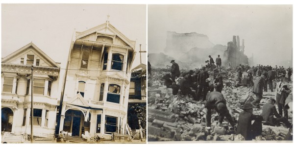
As a result, about 3,000 people died and over 80% of the city of San Francisco was destroyed. The earthquake and resulting fire are remembered as one of the worst and deadliest natural disasters in the history of the United States (along with the Great Chicago Fire of 1871 and the Great Baltimore Fire just earlier in February 1904).
The death toll from the earthquake and resulting fire remains the greatest loss of life from a natural disaster in California’s history and high in the lists of American urban disasters.
All photos by U.S National Archive


The 1906 earthquake preceded the development of the Richter magnitude scale by three decades. The most widely accepted estimate for the magnitude of the quake on the modern moment magnitude scale is 7.8; values from 7.7 to as high as 8.3 have been proposed.
According to findings published in the Journal of Geophysical Research, severe deformations in the earth’s crust took place both before and after the earthquake’s impact. Accumulated strain on the faults in the system was relieved during the earthquake, which is the supposed cause of the damage along the 450-kilometer-long segment of the San Andreas plate boundary.
The main shock epicenter occurred offshore about 2 miles (3.2 km) from the city, near Mussel Rock. Shaking was felt from Oregon to Los Angeles, and inland as far as central Nevada.
A strong foreshock preceded the main shock by about 20 to 25 seconds. The strong shaking of the main shock lasted about 42 seconds. There were decades of minor earthquakes – more than at any other time in the historical record for northern California – before the 1906 quake.
Widely interpreted previously as precursory activity to the 1906 earthquake, they have been found to have a strong seasonal pattern and have been postulated to be due to large seasonal sediment loads in coastal bays that overlie faults as a result of the erosion caused by hydraulic mining in the later years of the California Gold Rush


At the time, 375 deaths were reported, partly because hundreds of fatalities in Chinatown went ignored and unrecorded. The total number of deaths is still uncertain today, and is estimated to be roughly 3,000 at minimum.
Most of the deaths occurred in San Francisco itself, but 189 were reported elsewhere in the Bay Area; nearby cities, such as Santa Rosa and San Jose, also suffered severe damage. In Monterey County, the earthquake permanently shifted the course of the Salinas River near its mouth. Where previously the river emptied into Monterey Bay between Moss Landing and Watsonville, it was diverted 6 miles south to a new channel just north of Marina.


Between 227,000 and 300,000 people were left homeless out of a population of about 410,000; half of those who evacuated fled across the bay to Oakland andBerkeley. Newspapers described Golden Gate Park, the Presidio, the Panhandle and the beaches between Ingleside and North Beach as covered with makeshift tents. More than two years later, many of these refugee camps were still in operation