


Fra Mauro, an Italian cartographer who lived in the Republic of Venice, was a monk of the Camaldolese Monastery of St. Michael where he maintained a cartography workshop.
With strong dedication, long before the famous Earthrise photo taken by Apollo astronauts, he created the most detailed and accurate map of the world, the Fra Mauro Map, which is considered the greatest memorial of medieval cartography.

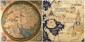
It was made around 1450, and it looks like a circular planisphere drawn on parchment and set in a wooden frame that measures over two by two meters. It took several years to complete and was very expensive to produce.

The map was not created by Fra Mauro alone, but by a team of cartographers and artists who were led by him. All together, they created the largest extant map from early modern Europe.

The map includes Asia, the Indian Ocean, Africa, Europe, and the Atlantic. It was likely influenced by Arabic accounts, as the map is oriented with South at the top because upon close examination of the map, the outline of the Mediterranean Sea, the boot of Italy, and the Black and Caspian Seas are clearly visible.

The map contains hundreds of detailed illustrations and more than 3000 descriptive texts. For the illustrations, Mauro used a range of expensive colors: red, brown, blue, turquoise, green, and black are among the pigments used. The descriptive texts describe the various geographical features on the map as well as related information about them.


Four smaller spheres surround the central circular map of the world:
- The top left sphere is a cosmological diagram – a map of the solar system according to the Ptolemaic system.
- The top right is a diagram of the four elements – earth is followed by water, fire, and air.
- The bottom left is an illustration of the Garden of Eden. Significantly, Fra Mauro took the step of placing the Garden of Eden outside the world, rather than in its traditional place in the extreme east.
- The bottom right depicts the Earth as a globe. It shows the North Pole, the South Pole, as well as the Equator and the two tropics.

At that time, only those who traveled could describe distant lands. Mauro listened to their stories and painted a portrait of our planet. The text on the map mentions many of these travel accounts. One of the primary sources were accounts of the journeys of Italian merchant and traveler Nicolo de Conti and the book of travels of Marco Polo, in particular about East Asia.
