


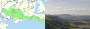
The advent of new technology has enormously increased the ability of the archaeologists and researchers to explore ancient sites in ways that were previously inconceivable. Courtesy of an extensive airborne laser scan, researcher have successfully mapped a region in southern England that was once used by the Romans as an important route of travel from Chichester to Brighton. The scans have revealed widespread farming networks on a scale that was unheard of. Researchers carrying out the scan and the study of the Roman road farming lands have hailed the findings, suggesting that they could force the historians to revisit the narrative of human history in Britain.
The Roman road in Sussex has long been a center of speculations regarding its nature and the lifestyle of the inhabitants along it, both before and after the Romans set foot on the island. The LiDAR technology was utilized to map carefully and analyse the remains of the Roman road almost fully obscured by woodland and has revealed some rather interesting facts about the life of Brits in the pre-Roman era. Historians held a notion about the farming capabilities of the inhabitants; one of very basic farming that could only yield enough crops for personal usage. However, the LiDAR scans point towards the fact that certainly there were farmers before the arrival of Romans in 55BC; they farmed on a much larger scale, industrial scale to put it in the right terminology.

The detailed survey of the land was made possible thanks to the lottery-funded initiative dubbed Secrets of the High Woods; an archaeology project of National Park Authority in collaboration with Chichester District Council and Historic England. Speaking about the importance of the findings, Mr. Trevor Beattie the CEO of the South Downs National Park Authority said that the results that emerged from the project have been astonishing and unexpected. The sheer scale of the farming networks, said Mr. Beattie, is now forcing the archaeologists to rethink the human history of southern Britain. Mr. Beattie added that the modern technology and LiDAR scans literally enabled the researchers to peel back the extensive woodland covering the historic sites; a feat that is practically impossible by the conventional methods of archaeology.

Archaeology officer at the Chichester District Council also expressed their amazement over the discovery and said that the woodland actually helped preserve the site; which have probably lain unscathed and untouched since the Romans left the region some 1600 years ago.
The level of civilization that is evident from these newly discovered farming networks is unheard of in the region around the Roman time. The sheer scale of crops grown in the region meant these crops must have fed a large portion of civilization. However, researchers have not found signs of any significant settlement in the region, which intensifies the mystery of the farming networks. Most of the historians associate the advent of modern civilization, such as constructing habitable structures and to some extent farming, to the arrival of Romans. However, the recent findings are clearly suggesting that the inhabitants of this part of Britain had already acquired civilization perhaps long before the Romans established their foothold in the region.