


Phantom islands can generally be divided into three groups. Most of the phantom islands recorded through history were usually derived and marked according to the reports made by early ship captains and sailors, during their missions to explore new realms. Many of the phantom islands in this category were later revisited and proved to be non-existent, or mistaken for some already extant island. In some cases, a group of icebergs played a trick to the unsuspecting sailors and made them believe they saw an actual island.
The second group of phantom islands is of purely mythical or fictional origin, but people decided to put them on the maps of the known real world. Islands such as Atlantis have been considered as existing and waiting to be discovered for a long time until modern geography deemed them to be products of imagination only (although the existence of some of them is still speculated).
The third category of phantom islands was intentionally “created.” In few cases from the past, people have been making false accounts of islands as part of a big scam. Isles Phelipeaux and Pontchartrain were named for Louis Phélypeaux, marquis de La Vrilliere, Comte de Pontchartrain, a government minister influential in allocating funds for additional voyages of exploration. He probably laundered some money through this fake islands. Another hoax like this is the alleged Crocker Land Island.
With all of this said, let’s look at some phantom islands mentioned through history. Some of them stayed on the maps for centuries:
1 Antillia

.JPG)
This phantom island is also known as the Isle of Seven Cities. The name Antillia probably comes from the Portuguese words “Ante-Ilha” (“Fore-Island,” “Island of the Other,” or “Opposite Island”). It was named so because it was considered that the island lays directly “opposite” from mainland Portugal (as it is usually charted) consistent with the Seven Cities story. The island was often depicted as a smaller version of the Kingdom of Portugal. The size and shape of it were almost the same as the kingdom.
The island of Antillia is one more mythical phantom island, and the idea for it comes from an old Iberian legend. According to the story, During the Muslim invasion of the Iberian peninsula in 714 AD, seven Christian bishops together with their communities, decided to flee. They embarked on their ships and set sail far into the Atlantic Ocean. After a long time spent on the sea, they found land (Antillia), and there they founded seven cities, one for each bishop and his flock. Those seven kingdoms were named Aira, Anhuib, Ansalli, Ansesseli, Ansodi, Ansolli and Con. After this, they burned down their ships as a sign of their independence.
The story about Antillia was nearly forgotten, but the rediscovery of the Canary Islands by Europeans in the 14th century proved that there is some undiscovered land in the Atlantic. This made the theory of the existence of Antillia (as well as other Atlantic islands) popular again.
Antillia appeared on a map for the first time in the 1424 portolan chart of Venetian cartographer Zuane Pizzigano. Here they are shown as part of a group of four islands, lying far in the Atlantic Ocean some 250 leagues west of Portugal, and 200 leagues west of the Azores archipelago. Some sixty leagues north of it is the large Satanazes island (more about this legendary island below). Antillia continued to appear in almost every nautical chart during the 15th century. After 1492 the Atlantic became mapped more precisely, and Antillia slowly disappeared from maps. However, this legendary place gave its name to the Spanish Antilles.
2 Atlantis

Atlantis is probably one of the most famous mythical lands/islands, and we have Plato to thank for it. In Plato’s works Timaeus and Critias, he depicts an antagonist naval power that besieges “Ancient Athens,” the embodiment of Plato’s ideal state. Although Plato only mentions Atlantis, its story would spread all across literature, especially among Renaissance writers, as a representation of a true utopian system. Plato only gave a few clues about Atlantis: he said it existed more than 9,000 years before his time, and he vaguely described the location of the island as “beyond the Pillars of Hercules.” This has led many people on quests to find this mythical piece of land.
There are two divided opinions about the existence of Atlantis: some think it is fictional and only used as an allegory, while others believe it was a real place, somewhere on the globe. Since the 1960s, with the theory of continental drift becoming popular, many scholars became convinced that a lost continent in the recent geological past is impossible. This approach benefits the people who think that Plato is misinterpreted. His real idea was that we should use the story to examine our understanding of government and power.
On the other hand, those who believe it to be a real place have speculated and offered many theories about the exact location of Atlantis. Since the 16th century, there have been multiple proposals and hypotheses about the site where the island is located: in or near the Mediterranean Sea; in the Atlantic Ocean; in Europe; Antarctica; in the Caribbean Sea; The Andes; India, and many others. This mysterious place has been literally moved across the whole world.
3 Crocker Land

Robert E. Peary was an American explorer who claimed to have conquered the North Pole in his 1906 expedition. In his book, he wrote that he saw some distant land from the heights of Ellesmere Island. He named this island Crocker Land, after his financial backer, George Crocker. It was later discovered that this claim was a hoax. In his diary entries from that time, Peary wrote that there was no land in that location. Following expeditions proved that the island doesn’t exist. It turned out that Peary invented Crocker Land to gain further support from Crocker and get more funding. Peary didn’t get the money after all, and Crocker Land remained a mystery and a subject of discussion. Other expeditions reported no such land, but people who trusted Peary still believed it could be found.
An expedition lead by Donald Baxter MacMillan was mounted to prove the existence of Crocker Land. On 21 April 1914, at the edge of the Arctic Ocean, MacMillan, and what was left of the expedition saw a huge island on the north-western horizon. MacMillan wrote that he saw “Hills, valleys, snow-capped peaks extending through at least one hundred and twenty degrees of the horizon.” Unfortunately, he was wrong.
Piugaattoq, an Inuit hunter that was part of the expedition, explained to him that it was just an illusion called “poo-jok” (mist). MacMillan didn’t listen and for five days he followed the mirage across the frozen ocean. In the end, they failed to find the island but managed to gather some valuable scientific information from the region.
4 Ernest Legouve Reef

This particular island was noted by an unnamed captain of the French ship Ernest‑Legouvé in 1902. Allegedly, it was about 100 meters long, accompanied by two other reefs in the vicinity. The reef was first recorded in Paris Notice to Mariners 164/1122/1902. In 1957, the reef was given an estimated geographical position: 35°12′S 150°40′W. Later, in 1983 an expedition was mounted to find the reef, but without any success. It was declared as a phantom island the same year. However, this didn’t stop the 2005 edition of the National Geographic Atlas of the World to mark it as existing place. The description and location of this reef are very similar to a rock mentioned at the end of Jules Verne’s The Mysterious Island novel:
“An isolated rock, thirty feet in length, twenty in breadth, scarcely ten
from the water’s edge, such was the only solid point which the waves of the
Pacific had not engulfed.It was all that remained of the structure of Granite House! The wall had
fallen headlong and been then shattered to fragments, and a few of the
rocks of the large room were piled one above another to form this point.
All around had disappeared in the abyss; the inferior cone of Mount
Franklin, rent asunder by the explosion; the lava jaws of Shark Gulf, the
plateau of Prospect Heights, Safety Islet, the granite rocks of Port
Balloon, the basalts of Dakkar Grotto, the long Serpentine Peninsula, so
distant nevertheless from the center of the eruption. All that could now be
seen of Lincoln Island was the narrow rock which now served as a refuge to
the six colonists and their dog Top.” – Jules Verne, “The Mysterious Island”
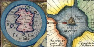
5 Friesland

The Isle of Friesland is another strange place from the Atlantic Ocean that can be seen on all of the maps from the 16th and 17th centuries. Friesland has been an elusive piece of land that has shifted its position many times. Before it appeared on the Zeno Map ( published in 1558 in Venice, by Nicolo Zeno), it had been confused with Iceland. This map placed it as a separate island south of Iceland. It must be noted that the Zeno Map was not a reliable source of information, mainly because it was full of phantom islands. This map was published with a bunch of letters that describe a long journey made by the Zeno brothers (Nicolo’s Ancestors) in the 1390s. They sailed through the North Atlantic and on their voyage, they allegedly docked spent some time on Friesland. The island appeared on the maps unchanged for the following 100 years. It was even recognized by famous cartographic authorities such as Mercator.
Friesland has been depicted as a rectangular island with three triangular peninsulas on its western coast. There were also some Italian toponyms scattered across the island. Eventually, Friesland became known and identified as the Faroe Islands. Even after it was recognized, both Friesland and the Faroe Islands appeared on some maps separated by hundreds of miles.
In some other cases, Friesland was confused with the southern part of Greenland. There’s one more case in which Friesland had been identified with an island called “Fer Island,” which was the old English name of Fair Isle.
6 Rupes Nigra

Rupes Nigra, or the “Black Rock,” is an island that was imagined as a 33-mile-wide black rock. According to some accounts, it was positioned at the location of the Magnetic North Pole or at the North Pole itself. It was mentioned for the first time in a lost book called “Inventio Fortunata” (Fortunate Discovery). According to this document, the Rupes Nigra was magnetic, and this is why compasses pointed to the (magnetic) North. The island appears mostly on maps from the sixteenth and seventeenth centuries. Apparently, even Gerardus Mercator was intrigued by it. Rupes Nigra appears on his maps as well.
7 Satanazes
.JPG)
It seems like the Atlantic Ocean was full of phantom islands and legends. Most of the legendary islands were placed here, probably because this vast area was mostly unexplored in those ages. The island of Satanazes (also known as the Hand of Satan or St. Athanasius) is another mystical place in the Atlantic. It has been drawn mostly on 15th-century maps.
It first appeared in 1424 on the maps of Venetian cartographer Zuane Pizzigano. He located it west of the Azores and Portugal, and just north of the legendary island of Antillia. Satanazes was depicted as a large, blue rectangular island, indented with bays and five or six settlements. Beneath it, there was an inscription saying: “this is the island of the devils.” This island, together with Antillia, Saya, and Ymana, were usually drawn together and known as the “Antillia Group.” On other maps, they appeared as “islands newly reported.” According to historians, the “devils” are probably a reference to the Skraelings (indigenous peoples of Greenland and Vinland) reported in the Norse sagas.
Another theory suggests that Satanazes and Antillia may be a representation of North and South America coasts. This approach may lead to a conclusion that there was a pre-Columbian trans-oceanic contact.