


During the years from 410 to 430 AD, the Roman Empire built a road over 3,000 km across Britain. The road has been recently rediscovered and was found in excellent condition. The road was found during construction work in the middle of Rochester and is now available for the world to see.

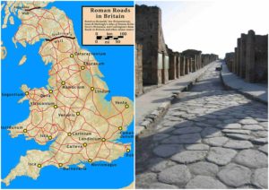
For over 400 years, the Roman Empire extended as far north as Britain. The Roman Army was thought to have created a road network that spanned over 2,000 miles to efficiently transport troops and war supplies throughout the empire. Even though the road was mainly built for military purposes, it also served as an economic hub for trade and the transport of valuable goods across the empire.
The roads the Romans built were excellent. Even though most of the roads laid down by the Romans have been lost, it is known that the roads were used by Britain for centuries after the Romans abandoned Britain. A few of the roads even remain part of the current road network in the UK.

The discovery started when a father and a son planned to convert a unit on the high street of Rochester into a store. When the pair bought the property, the previous owner indicated there could be an old road under the building. After the father and son had cleared away the debris, they found stonework by the edge of the cellar, and to their delight, it stretched to the other side of the room.
Despite the fact that many buildings were erected on top of the road, it survives in incredible condition over two millennia later. Only a small portion of the road had eroded, leaving it easy to fill with small amounts of chalk and lime. After further analysis, the Archaeological Society concurred that the roads were built during the rule of the Roman Empire. The road in the shop turned out to be four meters long and two meters wide. The road was covered with a glass case so people could walk along it without causing damage.
The Roman Empire fell apart many centuries ago, but thankfully a groundbreaking technique using high-tech lasers has shed new light on Roman roads and forts. The technology is called Lidar data; a method typically utilized for modeling floods. Since the Lidar data has been applied to the search, hundreds of meters of old Roman roads have been discovered across the north of England.

The discovery has cast new light on an often overlooked aspect of Britain’s long-lived, prosperous, and beautiful history. It is said that decades after the Romans conquered England, a large portion of the north was ruled by a tribe called the Brigantes. The history books refer to Tacitus, who documented the collapse of the powerful Celtic tribe. In the year 69 AD, Venutius organized a revolt resulting in Queen Cartimandua fleeing, and the gradual disintegration of the native tribes’ power.
For decades, the North of England pushed to connect its forts and towns through building roads. Travel was especially difficult given the rugged land, which led to a network of roads.
The new technology used to locate the Roman highways has turned up seven crucial routes over a short two-year period. The laser technology was combined with the use of airplanes and, due to the accuracy of the lasers, the height of the ground can be detected to sizes as small as five centimeters, making this the perfect tool to explore under the soil of Britain.