


A simple farmer did not expect to discover what appeared to be an ancient stone with Viking style graphic symbols engraved on it in the state of Minnesota.
Many people were saying he was lying or just simply crazy. Yet around 100 years later, more discoveries have proved the stele was actually the real McCoy. It was, however, actually left there by the Knights Templar instead of the Norsemen.
Not many books have ever really rewritten history, yet The Hooked X: Key to the Secret History of North America, by the writer Scott F. Wolter, is definitely one of them. The author of this revisionist book is a professional geologist and not a historian.
All these discoveries made by Wolter in the previous years and described in Hooked X are so powerful they make us rethink our views of the American past. The main focus of his revelations is that debatable, even contentious, artifact noted as the Kensington Rune Stone.

For those who are not familiar with it, this is a greywacke sandstone stele that weighs 200 pounds. It was found by the Swedish immigrant farmer, Olof Ohman, while he was clearing his land in the township of Solem, Minnesota, in September of 1898.
It was lying face down and was twisted around the roots of a 30-year-old aspen tree. The 30 by 16 inch slab was covered on the face, and one side had some sort of runic writing. Ohman brought it to the closest town, Kensington, where his discovery was put on display at the local bank.
A terrible copy of the engravings was sent to the University of Minnesota, where the translation was attempted by Olaus J. Breda. It took more than 100 years for scholars to correct the imperfect copy and to properly translate the text.
The front face had read, “Eight Gotlanders and 22 Norwegians on reclaiming/acquisition journey far west from Vinland. We had a camp by two shelters one day’s journey north from this stone. We were fishing one day.
After we came home we found 10 men red with blood and death. Ave Maria. Save from evil.” Engraved on the side of the stone were the words, “There are 10 men by the sea to look after our ships 14 days journey from this island. Year 1362.”

Professional Jump to Debunk Artifact
Though Breda was a professor of Scandinavian literature and languages, his knowledge was limited. He with haste proclaimed Ohman’s finding a transparent joke.
Breda was backed up by Norway’s head archaeologist of the late 19th century, Oluf Rygh – he and his coworkers at Northwestern University at Evanston Illinois proclaimed that the whole translation of the rune stone was entirely based on wrong analysis of the copy.
This ruined Ohman’s life in a time when a man’s word was truly his bond. He had never attempted to make any money off the rune stone. He often times cursed the day he discovered it.
He swore he had told the truth about the finding until the time of his passing. With his family reputation ruined, he was ridiculed and ignored by society to such an extent that one of his daughters committed suicide.
While archaeologists and linguists were still insisting that the Kensington Rune Stone was a fake, a geologist at the Minnesota Historical Society, Newton Horace Winchell, had taken a detailed physical examination of the object for the first time. The test he had done marked Ohman’s version of events.
Confirmed by the weathering stone, it was indicated the engravings were around 500 years old. Winchell concluded there was immense support for an actual rune stone dating back to 1362.
His report in 1910 was hidden beneath the louder words of the skeptics against him. They had convinced most of the world that the Kensington Rune Stone was forged. A few amateur archaeologists had their own doubts, and questioned if other local proof may support the rune stone’s truth.
For instance, they quoted the engraved text as it described the place of the rune stone to be located on an island, even though the item was discovered on a farm nowhere close to water.
It was not until 1937 when they stated doing hydrological studies that it was cocluded for the state of Minnesota that the area where the stone was discovered was flooded with lakes and streams during the 14th century, as well as the 500 years before that.
Dry conditions started to increase in the beginning of the 16th century, transfiguring the regional landscapes into marsh and swamps. It became a grand pasture by the time Olof Ohman settled there in the late 1800s. Neither he or anyone else knew at that time it was surrounded by water back in the year of 1362.
Investigators as well pointed out many triangular holes that were cut into the boulders. Evidently a very long time ago, along riverways going toward Ohman’s farm, the 14th-century seafarers were noted to favor triangular mooring holes.
Additional Finds
Not very far north and 27 years before the discovery of the Kensington Rune Stone, an old fire steel was added to the medieval Norse specimens located at the Oslo’s University Museum. It had been uncovered from the deep beneath the banks of the Red River near Climax, Minnesota.
Evidence such as this prompted investigators to seek out professional assistance of their own in 2000. They chose to contact St. Paul American Petrographic Services.
This firm specialized in the analysis of the materials used to construct the stone. It was to determine the specifications, conformance, and suitability or the causes of failure.
It was and is still owned and headed by Scott F. Wolter, who is a certified geologist, university trained, who previously did not hear of the Kensington Rune Stone. He conducted the first detailed physical analysis since Winchell’s research 90 years before.
With no ideas or preconceived notions, he came up with a different outcome from his research. Wolter started using photography with a reflected light microscope. He would sample the core and examine it through a scanning electron microscope.
In the month of November, he presented his main discoveries. This alleged artifact had signs of a subsurface erosion process that required a minimum of 200 years. In simplified terms, the Kensington Rune Stone was buried for around a century before Olof Ohman had dug it up.
Wolter’s end result was based on the full breakdown of mica crystals on the engraved surface of the stone. Compared to the gathered samples of slate gravestones from Maine, these show that biotite mica starts mechanically flaking off the surfaces after 197 years. Skeptics set out to fault his resolution by arguing that standards for mica degradation did not exist.
He responded by to that by saying that there was no standard for the mica degradation work that he had performed on the rune stone since to his knowledge he was the first to perform this kind of relative age dating examination.
Interested, he started to examine each individual rune with a scanning electron microscope. This revealed many remarkable characteristics not seen to the naked eye.
Also noticed is a hitherto unseen series of dots carved inside three R-runes. This finding was very significant, for the reason that dotted runes only occur on the head stones of 14th century graves. They were located in church cemeteries on the island of Gotloand, which was off the coast of Sweden. The rune stone text goes back to the same century and references eight crewmen from Gotland.
Smoking Gun
Wolter then studied and copied the rune stone from the first geologic report released in 1910. Early 21st century technology firmly established Prof. Winchell’s conclusion that the artifact was indeed authentically pre-Columbian. The finding of a single runic letter “the dotted R” was not identified to scholars until 1935.
But it was discovered on the rune stone that was discovered in the year 1898. The stone engravings could have only been carved during medieval times.
Leaving no doubt of the verification of the Kensington Rune Stone’s 14th-century identity was indeed a true scientific triumph. It confirms beyond a doubt that the Scandinavian seafarers arrived in North America 130 years before Christopher Columbus had left Span in hunt of a new world.
Yet Wolter broadens his studies to unveil much more. He had found out that the rune stone was not just some pre-Columbian object, but it proved that the Norse had beaten the Spaniards to America. He has ultimately defined it as a land claim marker.
This means the men who had left it were declaring for themselves what later turned into west central Minnesota. The inscription’s date of 1362, Wolter demonstrates, was in addition to the encoded in the runic text itself. The Arabic numerals were defenseless to alteration by interlopers.
After the carving, the stone was buried, a triangular formed hole was drilled into glacial boulders nearby. These were used to relocate the exact position of the buried stone. The directional marker holes have no firm evidence, but were discovered – they still indicate the primary location of the rune stone’s finding by the man Olof Ohman.
Wolter decided to go further into his quest for information about the artifact to find the identity of the man who engraved the inscription – the Cistercian monk from Gotland mentioned in the runic text. The Cistercians lived under religious vows as Gnostic Christians.
They were the founders of the Knight Templar and survived its destruction during the 14th century. They migrated from France to other places in Europe, including Gotland. Templars were still settlers of the island at the period of time the Kensington Rune Stone was carved. Wolter claimed the inscription included information that was related to who the party was, where their exact location was, why they were there, and when.

The Hooked X
The key to unlocking this information was the mysterious hooked X that appears on the rune stone as well as other runic texts in Europe and pre-Columbian North America.
Wolter has explained the hooked X was a symbol that was important and likely made by the Cistercian monks. The X was a symbol of the balance and duality of woman and man, and heaven and earth.
The hook that is in the X symbolized the offspring or children, representing the continuance of the Goddess belief through common thought and bloodlines.
This specific glyph is helpful in the verification of a runic inscription. It is highly unlikely to have been known to a hoaxer and it appears on a few artifacts. It has been dated back to the late Middle Ages, and this is helping to create not only the truth of the stone, but the time the particular rune was made.
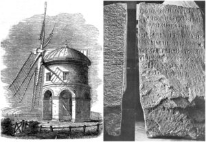
Wolter gave us the Kensington Rune Stone amoung other, linked finds. Among the best noted is Rhode Island’s Newport Tower.
Appointed by mainstream archaeologists to be nothing more than a ruin from the 17th century mill claimed to be owned by the family of Benedict Arnold, the stone building in Touro Park, as Wolter demonstrates, was created using architecture that is not conformable to pre-Colonial construction before the first noted recording in Benedict Arnold’s will in the year of 1677.
For example, the standard unit of measurement used in construction through all New England in the 17th century was the English foot. The Newport Tower was laid out in the Norwegian short alen, so it was not created by the 17th-century colonists.

Mysterious Tower Explained
He quotes the procedures that were applied to the 1997 structure by the Danish professor Andre J. Bethune. The carbon 15 examination displayed that the Newport Tower was standing throughout the years of 1440 to 1480.
Wolter displays the near resemblance to the sacred structures located in medieval Europe and the Near East, Scotland’s middle 12th century Eynhallow Church located in Orkeney, or Jerusalem’s Templum Domini. These determine the baptistery was additionally employed for navigational reasons.
James Whittall pointed out that the tool marks made in the dressing out of the stonework of the Newport Tower can be directly linked to tools in use before 1400. These marks are unknown and uncharted when compared to tool marks recognized in Colonial stonework.
The single and double-splay windows have prototypes within medieval Europe and in the northern isles of Scotland in the 1300s in bishops’ palaces and the churches in Orkney. The walls have been covered with a stucco finish, both exterior and interior. Stucco was added in the 1200s, and is featured in Orkney and Shetland.
It is assumed that Prince Henry Sinclair was involved in the building of the Newport Tower. This is believed because the architecture of the tower has similarities to that of northern Scotland, where Prince Henry had ruled.
Some other researchers have proposed units of measurement that were used to create the tower were either the Norwegian alen or the Scottish ell. Several researchers have noted that the tower’s double flue system in the fireplace is comparable with medieval Scottish architecture. Numerous other details leave no doubts that the tower was a provenance of pre-Columbian peoples.
Hoax Unlikely
Among the least known, but most convincing, finding of its type is a one line, lithic inscription discovered close to Pojac Point in Narragansett Bay, a large river on the north side of Rhode Island Sound. The mostly drowned, two ton, glacial boulder is in a challenging position around 60 feet from shore.
The waters are often rough for the pre-Columbian, which says much for the runes etched onto its top. It extends beyond above the surface of the sea and is frequently washed by the wave action. These kind of conditions argue strongly against the possibility of a hoax.
Wolter had discovered that each of the nine gyphs was around two inches long and one-half of an inch deep. The first rune contained a version of H that dated to the late Middle Ages. The period that was suspected is confirmed when a telltale hooked X was found in the Narragansett Stone. Its place in New England’s biggest river, which functions as a wide area natural harbor, tends to support the possibility of visiting seafarers who used this place as a headquarters to navigate the interior.
Other hooked X specimens were found far from the Narragansett stone in 1971. They were discovered buried alongside the shores of Spirit Pound close to Popham Beach. This is not far from the Maine coast.
Other accidental finds, unfortunately made by an unaccredited person, the three Spirit Pound stones were automatically deemed fraudulent by mainstream opinion.
They were put into the Main State Museum located at Hallowell. There Wolter had taken around 1,700 images of them from 2006 to 2007. His analysis displayed that one of the stones was illustrated with a map.
It was oddly oriented with east at the top and north to the left; this is something a forger would have not been likely to do.
Until 1500, medieval maps were similarly oriented to the location of Jerusalem, putting the east direction at the top. Wolter’s coworker, an amateur linguist known as Richard Nielsen, had already made a firm decision on a date of 1401 from the Maine artifacts runic texts.

The Westford Knight
Not too far from the Tyngsboro Map Stone, in the same county, is a Massachusetts location he investigated in the Westford Knight, who had allegedly decorated the ice mass on the striated, mica schist bedrock. The picture has been familiar to generations of Westford settlers, yet it has only been professionally photographed for the first time following World War II.
The discoveries were publicized shortly after in The Ruins of Greater Ireland and New England by Meador Press in 1946. To protect the location, Goodwin did not reveal its actual position.
Several years after his passing, a committed reader known as Frank Gylnn, discovered the image, which was made by punch holes created with a hammer. The irregular illustration was supposed to portray a helmeted a knight at arms with a shield and sword.
When Wolter analyzed it in 2006, he was not able to make out anything that resembled a human figure, possibly because it is worn away in the decades of exposure to the elements after moss covering the illustration.
He ultimately clearly discerned the depicted outline of a broadsword which, according to historian Michael Kaulback, was identified by British antiquarians as a big wheel pommel blade of the 14th or 13th century. This would make the image concurrent with the Minnesota’s Kensington Rune Stone.
A short walking distance from the Westford Knight, the JV Fletcher Library shows a 300-pound glacial granite boulder with a picture of a sailing vessel in the company of three gyphs and an arrow.
These artifacts have turned into something invaluable for the validation of their pre- Columbian origins, all because of an professional geologist and accredited scientist. He has removed them from the speculation of amateur theorists.
Most importantly, Scott Wolter shows that they are fragments of a puzzle far greater than the individual parts. The bigger picture is the credibility from his analysis that unveils the astonishing extent and depth of the Norse impact on our continent long before Christopher Columbus was born.
Vinland Map Authentic
Importantly, as the first copies of The Hooked X were published by the press, every word the author wrote was being underscored by Rene Larsen, who was rector of the School of Consercation located at the Royal Danish Academy of the Fine Arts.
Last July he and his colleagues, who were all world class authorities in their respective fields, proclaimed during Copenhagen’s International Conference on the History of Cartography that the Vinland Map was real. Their five year examination generally accepted that this document was the Norse voyage to the exploration of North America starting after 1000 AD, American Free Press reported.
The map had displayed land masses that were identified as the Vinilanda Insla. It encompasses an area from Maine located in the north to the Carolinas in the south, as well from the Atlantic seaboard to the Susquehanna River in central Pennsylvania.
The starting line in this book, opening a short introduction by Niven Sinclair, asserts, “History needs to be rewritten.”