


In Toronto, Canada, Live Science reports that 12 or more circular geoglyphs of different sizes have been documented in southern Peru, close to the ancient town Quilcapampa.
Several of the pictures, dated back to between 1050 and 1400 AD, were made by removing stones from the surface of the ground.
Justin Jennings of the Royal Ontario Museum and his colleagues have mapped the intertwined rings with satellite imagery, ground surveys, and aerial drones.
They have discovered they were placed close to trade routes.

The researchers propose that the circular pictures might reflect the continuous movements of the food, goods and people along the route that linked the highland and the coast.
Several of the geoglyphs are accompanied by rock piles or cairns that are part of the design.
Geoglyphs are designs that are often forms or images located on the landscape.
They are discovered all around the world.
The most noted examples are located at a place known as Nazca, where there are thousands of designs in geometric shapes and engraved into the Peruvian desert.

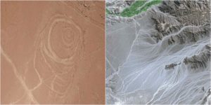
They have discovered that several of the geoglyphs at this location have a simple one ring design, while others they have discovered are more complicated.
One of the geoglyphs they mapped had at least six rings that were designed in an irregular pattern.
It had smaller circles embedded inside bigger circles so that the design appears like a little swirl.
As well, several of the geoglyphs include rock piles called cairns located within or beside them.
The size of the geoglyphs differs considerably.

One of the rings of the geoglyphs is 6.6 to 13.1 feet (2 to 4 meters) in diameter.
Some of the multiple-ring geoglyphs measure over 800 square meters, around the size of two NBA basketball courts.
A majority of the geoglyphs were created by removing stones from the surface to expose the sandy soil that is below it.
To archaeologists, it is still a mystery to why the people of Quilcapanpa had often used circles in their geoglyph designs.
It seems that no writing system had existed in Peru at that time to even offer a possible explanation, Archaeology reported.
Throughout the time that Quilcapampa flourished, there was a lot of interaction between the highland and the coasts.
This summer the researchers will continue their examination at Quilcapampa.
Here is another interesting read from us: 3,000-year-old leather working tool found on a beach
The squad’s work is supported by a grant from the National Geographic Society’s Committee for Research and Exploration.