


Maps have shaped not only our mere geographical interpretation and understanding of the planet earth, the institutions accelerated the progress and played a significant role in the anthropology throughout the history.
The earliest known existence of world maps goes back to the classical antiquity and oldest artefact resembling a map comes from the 5th and 6th century BC, and were predominately based on a flat earth paradigm.
However, maps were based on the spherical earth understanding of the planet appeared in the Hellenistic era. This was primarily due to the development in the Greek geography during the Hellenistic period, mostly by the Posidonius and Eratosthenes that culminated in the Roman era with the legendary Ptolemy’s map of the world that appeared in the 2nd century AD. This Ptolemy’s world map remained the most authoritative depiction of the world’s geography all through the Middle Ages.
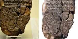
A world map from the Babylonian era is known as the Imago Mundi, has been dated to the 6th century BCE; this is considered the oldest map of the planet discovered so far.

Since the Ptolemy, the formation of the maps, the application of which ranged from exploration to trade and invasions, largely depended upon the approximation of the size of the globe that allowed the cartographers to make the estimation regarding the extent of their geographical understanding of the planet.
Within these maps the makers mainly split the globe into known territories and the unexplored regions were known as terra incognita. Fast forward to the 18th century, and the map making had dramatically improved thanks to the age of discovery that started in the 15th century, and these maps became increasingly accurate. The accuracy of maps helped explorers step foot on the uncharted territories such as interior Africa and Antarctica in the 19th and early 20th century.
The Babylonian map of Imago Mundi is a rather simplistic and diagrammatic depiction of the known world as observed or perceived by the Babylonians. Incised on a tablet made out of clay, the map put Babylon to the north of its centre while branches stemming out of the centre towards other parts of the circle depicted other known regions.

Historians suggest that the places and island locations depicted on the ancient map, could possibly reflect the real places out of Babylonian knowledge, but probability suggests some of these places could may as well be purely mythical. At the time, there were no clear distinctions between real/explored places and mythical lands, hence the possibility of some mythical places that later turned out to be real places could not be ruled out.
One interesting aspect of the map is that though the prevailing knowledge about the shape of the earth, as suggested by many historians, was based on a flat earth model, the Imago Mundi is, in fact, a map in a circular form though not necessarily suggesting a spherical understanding of globe.

Although the tablet is partly damaged, the cuneiform text depicting the places on the map are clear enough to make up the nature of the content of the tablet as a map and not just any other artifact.
Historians have dated back the Imago Mundi to the 5th century BCE, after it was discovered near Sippar in the southern region of modern Iraq; some 60 miles north of the Babylon located on the eastern bank of the Euphrates River, the findings of the tablets were first published in 1899. Currently, the tablet is residing at the British Museum under the reference (BM 92687).