


The Black Sea is known as a famous inland body of water surrounded by six countries. Of all the amazing facts about the Black Sea, those surrounding a recently discovered ship graveyard can be added.
The Black Sea received its name due to inhospitable waters and is home to more than 40 shipwrecks. The shipwrecks are from the Ottoman and Byzantine period. The fortuitous discovery was stumbled upon by an international expedition team led by the University of Southampton. International experts went intending to map the underwater seabed of the Black Sea.

As the exploration reached the dead zone, the amazing discovery was made. The team had acquired the most sophisticated deep water equipment of our time, and this new discovery allowed them to put their equipment through its paces like never before. They have provided some detailed and intricate pictures like never seen before and hopefully these images will provide new information on the communities on the Black Sea coast. They are able to take astonishing pictures without disturbing the seabed. The advanced underwater equipment can reach depths of 5,900 feet (1,800 meters), to begin the extensive survey of the seabed.
Many of the colonial and commercial activities of ancient times centered on the Black Sea. In 1453, Constantinople changed its name to Istanbul and the Black Sea was closed by the Ottoman Turks. Foreign commerce eventually ceased until 400 years later. In 1856, it re-opened to the commerce of all nations due to the Treaty of Paris.
The team assembled by the Center for Maritime Archaeology from the University of Southampton was led by Professor Jon Adams. The project’s purpose was the mapping of the sea floor to resolve hotly contested theories surrounding the former land surfaces buried below the current sea bed, and to determine exactly when, after the Ice-Age, the water level rose, how quickly it did so, and its impact.

At the same time the team discovered a treasure trove of shipwrecks. Not just any ships – ships from ancient civilizations that were a huge surprise. The project known as the Black Sea Maritime Archaeology Project (Black Sea MAP) involves extensive mapping of the seabed of the Black Sea. What they discovered vindicated many archaeologists’ claims as the equipment scoured the “dead zone.” The dead zone has long been claimed to contain a mass graveyard of ships, and now the evidence has been uncovered. Many archaeologists can feel vindicated as they have now been proven correct.
Dead zones are areas where there is completely no oxygen (anoxic). Due to this, the trove of shipwrecks were well preserved as the rate of decomposition is slow.
Professor Jon Adams, the lead investigator, said that the project’s aim was to map the seabed by the geophysical survey to better understand the changing landscape after the last Ice-Age. The ships they stumbled upon were an added bonus and an opportunity to test their high-tech equipment’s 3D scanners and cameras.
The expedition’s real purpose may not have changed as the Surveyor Interceptor was put through its paces, from seeking to know when the water levels rose, to 3D scanning of sunken ships never seen before.
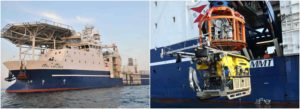
The Surveyor Interceptor and its compatriot are stored aboard the Stril Explorer. It carries some of the most advanced underwater survey systems. These platforms provided an in-depth look at an ancient world now residing at the bottom of the Black Sea.

Surveyor Interceptor, one of two Remotely Operated Vehicles (ROV’s), has reached depths of 5,900 feet (1,800 meters). While Surveyor Interceptor “flies” at sustained speeds of over 7 mph (six knots), its compatriot is equipped with high-powered equipment such as the 3D scanner. Since the beginning of the project, it has covered 776 miles (1,250 kilometers). These are all new records which they can be proud of; the rare find is a bonus.
Professor Adams’ team are the best exponents of this methodology. No one else has come close to the completeness of the models produced by him and his team. The 3D recording of the wrecks are an astonishing incentive and an undoubtedly fascinating discovery made during their extensive geophysical surveys.

Facts about scanning the Black Sea Bed:
The researchers were equipped with two Remotely Operated Vehicles (ROVs).
ROV One is a highly specialized 3D photographer, and Surveyor contains an entire suite of geophysical instrumentation as well as lights, high-definition cameras, and a laser scanner.
Surveyor Interceptor “flies” at four times the speed of conventional ROVs.
A collection of more than 40 shipwrecks were discovered; the ROVS were used to inspect the wrecks and provided the first views of ship types never seen before, Mail Online reported.
Down in the deep, dark dead zone of the Black Sea, an international team with high-tech equipment has revealed the past long forgotten. The Black Sea and its unique make-up is hiding more answers to the understanding of the people who once called the Mediterranean coastline home.