


Mount Tarawera is a volcano on the North Island of New Zealand just 24 kilometers from Rotorua, which is a hydrothermally active area even today.
The volcano is thought to have erupted in 1315, but it’s unknown as to whether or not anyone was living in the area at the time. The amount of ash thrown up from this event would have drastically changed temperatures around the world – enough to have started the Great Famine in Europe that lasted from 1315 to 1317.


The next major eruption of this volcano came in 1886, just after midnight on June 10th. It was one of the largest eruptions New Zealand had experienced in its history, lasting six hours and causing widespread destruction and death. People woke to earthquakes, fountains of molten rocks, lightning, and columns of ash and smoke up to 10 kilometers high in the air.
The eruption was heard halfway down the South Island, and the destruction was extensive – the land was covered in tons of ash, lakes were transformed, and bushland was flattened. The pyroclastic flow traveled six kilometers, destroying everything in its path. Six settlements were inundated or destroyed, including Te Wairoa, which became known as the “buried village” and is a tourist attraction today. Villagers from Te Wairoa survived by huddling in a wharenui (Maori meeting house), which was later removed and displayed in England at Clandon Park.


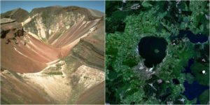
Over 120 people died that night as a direct result of the eruption; most were in the villages that had been at the base of the mountain. The mountain destroyed the famous pink and white terraces, one of the World’s Scenic Wonders; where they had been was afterward a 100-meter deep crater that eventually filled in to make the much larger Lake Rotomahana.
Since 2011, some of the terraces have been discovered at the bottom of the lake. It is said before the eruption a ghostly canoe was seen on the waters of Lake Tarawera by both Maori and Europeans. It is thought that the next time the volcano is due to erupt, the ghostly canoe will return with its warning.

It was not known at the time that Tarawera was an active volcano. The only warning sign of the imminent eruption was a rise in Lake Tarawera’s water level and an increase in thermal activity in the area.
Read another story from us: Mysterious objects wash up on New Zealand beaches
The rift created by the eruption was 17 kilometers across, and you can still see the scars on the landscape today.