


In New Mexico’s Chaco Canyon just northwest of a Navajo reservation, the remains exist of what was once a series of great houses erected by the Chacoans. These were ancestors of Pueblo Native Americans, also called Anasazi.
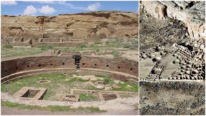
In its heyday, Chacoan society covered the four corners area– New Mexico’s San Juan Basin and parts of Arizona, Utah, and Colorado. Pueblo Bonito (“pretty village”) is the largest of these sites and shows evidence of ancient roads that connected smaller “suburb” locations in the canyon.

This arrangement hints that the houses were part of a large city complex. Professor Douglas Kennett of the Pennsylvania State University remarked, “All societies are complex, but here we see a society with larger populations living in villages and cities and where major differences in status and wealth are evident.”
The Chacoans built the structures using masonry, and they often included hundreds of rooms in their multi-storied buildings constructed sometime between 828 AD and 1126 AD. The buildings were planned out in their entirety, but often took generations to complete. The structures included ceremonial rooms, living quarters, public gathering areas, and burial chambers. The elaborate burial chambers were for the highest members of society. At least 32 kivas, or underground rooms, would have offered relief from the hot desert sun during meetings and rituals.

The United States acquired the Southwest region in 1848 after the Mexican War. The U.S. Army conducted a survey there, but due to the remoteness of the area and its lack of natural resources, not much attention was given to the ruins. Then in the 1870s, members of the Smithsonian Society brought the ancient site to the public’s attention. In 1896, the Hyde Exploring Expedition, under the sponsorship of the American Museum of Natural History, began excavations. Within five years they uncovered more than 60,000 artifacts that were sent to New York for study.

In 1901, Richard Wetherill, a colleague of the Hyde group, decided to claim 161 acres of the Canyon for himself, even though the area included several of the ruins sites. Due to Wetherill’s overly ambitious takeover of Native American lands, the Chacoan sites were charted by Edgar Lee Hewett from New Mexico Normal University the following year. It was his actions that prompted the Federal Antiquities Act of 1906, for the protection of ancient relics. This, in turn, led to Theodore Roosevelt’s March 11, 1907, declaration of the Chaco Canyon National Monument. The Monument was placed on the National Register of Historic Places in 1966.

The Chacoans did not have a written language, which makes their society much harder to study than that of, for example, Ancient Greeks or Egyptians. When DNA tests became possible, they were used to explore the lineage of the remains found in one of the burial chambers.
Evidence shows that the society in which these people lived was matrilineal. Power was in the hands of women and passed on to their daughters and female descendants for more than 300 years. The test also revealed that all of the remains possessed the same mitochondrial genome, which tells us that the female leaders were descended from the same female ancestor, Mail Online reported.

Pictographs on the structures also suggest that the populace witnessed the supernova that happened in July of 1054 AD. One particular image shows the precise positions of the moon and the supernova when it would have been at its brightest point.
The imprint of a hand above the moon symbolizes a sacred place. Most likely, the area was deserted by about 1130 AD, possibly due to a natural occurrence such as drought.