


Digitizing old books is a complicated process, involving much more than just scanning and photographing materials. It requires a lot of skill, patience, dedication, and effort; such is the case with the Klencke Atlas held at the British Library in London.
The experts working on the project took the process of digitizing books to a whole new level when they transferred the entire 357-year-old book to a computer screen.

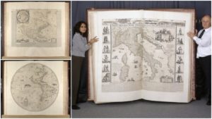
The biggest problem they faced was not the fact that the Klencke Atlas is nearly four centuries old, but that it is also among the world’s largest books. It stands at nearly six feet tall and measures more than seven feet wide when open.

It takes six people to lift the book, which was the world’s biggest atlas until the publication of the Earth Platinum Atlas in 2012. Experts designed a special stand for the book and worked for days to complete the digitization process.

Containing 41 copperplate wall maps, the Klencke Atlas is undoubtedly the most valuable object in the British Library’s cartographic collection.
The story behind the Klencke Atlas is more fascinating than just an explanation of its size. At the time when it was produced, maps were considered as important as fine art. According to an article published by The Guardian, maps were an important status symbol in the 17th century. Many wealthy people owned a map of the world to show their worldliness or a map of the Holy Land to show their piety.

The Klencke Atlas was named after Johannes Klencke, a professor of physics, metaphysics, logic, ethics, and politics at the Athenaeum Illustre of Amsterdam. He offered the giant atlas to King Charles II as a gift in 1660, in an attempt to gain favorable trade agreements with Britain for exporting sugar from Dutch plantations in Brazil.

Charles II, himself a map enthusiast, was apparently quite impressed with the gift and immediately placed it in his private cabinet of rarities. That same year, Klencke earned a knighthood and was likely successful in securing the trade agreements he came for.

According to Tom Harper, lead curator of antiquarian maps at the British Library, Count Johan Maurits of Nassau-Siegen is credited with the conception of the Klencke Atlas. In his article about the giant tome, Harper writes that Maurits was a very influential man in the courts of Europe and a great patron of art and science during the Counter-Reformation period. Maurits was governor-general of the Dutch West India Company in Brazil from 1636 until 1644.
The Klencke Atlas was not the only atlas created by Maurits. He is known for presenting other slightly smaller atlas known as the Great Elector’s Atlas to the Elector of Brandenburg in 1664 and the Rostock atlas.

Most of the 41 stunning maps were made by Joan Blaeu, one of the most prominent Dutch cartographers of the 17th century. His father, Willem Blaeu, was also a famous cartographer, and when he died in 1638, Joan took over his studio and eventually became the official cartographer of the Dutch East India Company.

The Klencke Atlas also contains Hugo Allard’s map of the British Isles and the works of several others, including maps drawn by Cornelis Danckerts, Jacob Colom, William Hondius, Melchior Tavernier, Nicolas Sanson, Jean Jubrien, Nicolas Visscher, Jacob Colom, and Petrus Bertius.

For nearly 170 years the Klencke Atlas remained part of the royal collection, until King George IV gave it to the British Museum in 1828 as part of a larger geographical collection owned by his father George III.
The atlas was completely rebound and restored in 1961, and since 1998 it has been housed in the British Library. It is now displayed in the lobby of the maps reading room.

Harper told Hyperallergic that the main reason for the digitization project was to increase public access to the 41 maps by making them available for free online.
He added that the digitization would enable researchers to study its miracles of Dutch cartography.