


The biggest Renaissance-era map of the world known to exist, so large that it is drawn on 60 separate sheets of manuscript, has, for the first time, been put on display in the way its creator, Urbano Monte, intended.
Monte, born in 1544, designed this beautiful piece of artwork to be more than just a map; among the drawings of fantastic creatures, both real and imaginary, Monte’s planisphere (meaning the projection of a sphere on a plane) portrays a collection of scientific information, including indications of “climate, customs, length of day, distances within regions.” The intricately hand-drawn map bears the date 1587.
For 430 years, the map has been bound as an atlas containing 60 sheets designed to be joined together to form a map almost 10 feet square, plus a key sheet and several additional sheets, such as a diagram of how an eclipse of the sun occurs. It was Monte’s intention that his map should be pieced together and displayed on a board with a pivot at the center, allowing it to be rotated. And now, thanks to modern digital imaging, his vision has finally become a reality.

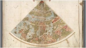
The map, described by Bonhams Auctioneers as a “Manuscript wall map in atlas form…sepia ink and wash on paper, heightened in gold and silver,” was bought by David Rumsey, founder of the recently opened David Rumsey Map Center at Stanford Libraries, part of California’s Stanford University. Rumsey donated the map to the collection last year. With the assistance of his nephew, he has painstakingly scanned each tavola, or image plate, and digitally stitched them together into a single image, revealing a splendid bird’s eye perspective of the world as Monte knew it. Its vantage point is the North Pole. The results of their work can be viewed on the David Rumsey Map Collection website, where you can examine the detail of the individual manuscript sheets, as well as view and rotate the composite virtual planisphere.

One of the most striking aspects is the advanced cartography skills that Monte used. The map is circular and longitude lines radiate outward from the North Pole, a style of map known as an azimuthal projection. It shows our planet as if it would have been seen from the North Pole looking down from space, a perspective not widely used by cartographers until the 20th century.
“I think Monte was really trying to show the circular nature of the Earth,” said Rumsey. A map positioned in such a way offers a more accurate depiction of the landmasses extending in the northern parts of our world, but it also makes Antarctica look exaggerated. Rumsey explains how this was in line with the cartography-making logic of the era: “Most cartographers thought it had to be massive to counterbalance the large landmasses to the north.”
Monte drew his geographical knowledge from the works of famous mapmakers of the time, and he made sure to include fresh discoveries made by explorers, an example being the islands of Tierra del Fuego, which were first discovered by Ferdinand Magellan’s fleet in 1520. His depiction of Japan, which takes an unusual shape and wrongfully extends from east to west instead of north to south, includes many place names not shown on maps made by his contemporaries. It is assumed that his knowledge came from a meeting in 1585 with the very first Japanese delegation to visit Europe.

Not much is known about the life of Urbano Monte, a nobleman from Milan. He came from an affluent and well-established family, something that allowed him to spend a lot of time in his prominent library, pursuing his scholarly interests. Like many gentlemen of the era, a period when Europeans were exploring more and more of the globe, he had a keen interest in geography. It seems that creating this map was Monte’s way to consolidate his understanding of the world around him.
And it is a world which looks spectacular. The map shows vivid representations of various animals and mythical creatures, something that was common practice among cartographers at that time, especially to fill in the blank spaces in areas that little was known about. A camel stands in the heart of Africa, as beautifully depicted as the demonic creatures and unicorns that make Siberia all the more mysterious. Giant birds can be spotted over the South American continent, and a sea-monster pops out of the ocean just off the coast of Venezuela.

There are a number of portraits of notable important European people. “Certain political figures are also highlighted. Monte lived during the reign of Philip II of Spain and the power of the Spanish empire is evident across the globe: several Spanish armadas can be found from Atlantic to Pacific,” notes Katherine Parker, a cartography historian who discusses Monte’s map in her recently published essay, A Mind at Work. Monte’s self-portrait from 1587, the year the map was completed, is covered with a later portrait that was drawn two years later, when he was 45 years old. Experts believe that he spent these two years making final revisions to his detailed work.
G. Salim Mohammed, curator of the Stanford based map center, has described Monte’s work as a “cartographic manuscript masterpiece.” Commenting that the map is unique in numerous ways, Mohammed also stated that “No one has really studied this because it’s been hidden for centuries.” Monte’s map is considered to be an important resource for historians as it provides much detailed information about scientific advances, political influences, and geographical knowledge in 16th century Europe.