


Nature has a way of creating art, and unusual geological formations found in many places on Earth prove it. In China, there is the Stone Forest of blade-like limestone columns, many of which are taller than 30 feet. These spectacular natural stone formations are said to resemble trees, animals, people, even fungi.
Part of the coast of Northern Ireland is famed for the Giant’s Causeway, a terrain composed of some 40,000 basalt columns. These peculiar formations were created by volcanic activities in the distant past, and some of the tallest measure 39 feet in height. From the highest ones, the columns descend towards the sea, where they disappear under the waves.
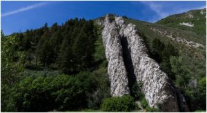
While both the locations mentioned above are designated as UNESCO World Heritage sites, we cannot say the same about the Devil’s Slide in Utah. This particular rock formation has inspired the name of a small town in the past, and it is a compelling natural landmark to visit. It can be found on the south side of Interstate 84 in Weber Canyon, near the community of Croydon in the north of Utah, not very far from the border of Wyoming.

First mentioned in a newspaper story in 1875, the Devil’s Slide is a perfect case of how erosion processes and changing weather conditions affect distinct layers of rock due to their different composition. The two prominent rock slides from the left and right have become very hard over time. Both these segments are resilient to weather, which is how they have preserved their height of about 40 feet.
In length, the slides extend hundreds of feet, almost vertically racing down the side of the mountain, while in between the two slides there is a space of some 25 feet. The in-between space that lurks in the shadows of the slides is softer limestone and more prone to erosion, which is why the entire structure looks like a sloping channel.

It has undoubtedly taken the Devil’s Slide millions of years to form and reach its current appearance. Geologists have explained that the formation is a remnant of tilted sediment that was deposited in an ancient sea that once (around 180 million years ago) claimed the territories of what is nowadays Utah, Montana, Wyoming, and northern Arizona.
Processes of mountain formation that began some 75 million years ago must have helped the limestone segments gain the almost-vertical position, after which erosion did its trick in giving the current morphology of the Devil’s Slide.
When pioneers first roamed the area sometime in the mid-19th century, they would refer to the area of Croydon as “Gutter Defile,” probably thanks to what a few decades later become known as the Devil’s Slide. It is presumed that the name of the formation was given by a railroad worker named James John Walker, whose family has been one of the first to come to live in Croydon.
According to the family history of Walker, James John was working on railway tracks in the region, likely in 1868, when some of his colleagues asked him to give a name to the strange rocky chute–his answer was Devil’s Slide. The name stuck.

In the early 1900s, the formation gave its name to a town founded nearby. The region was noted for its rich limestone resources, something that would spur a business to produce concrete. A group of investors opened a corporation called rhe Union Portland Cement Company and then a community that was mostly for company employees.

The town was initially referred to as Portland after the company. But, as the Standard-Examiner reports, workers were opposed, preferring the name of Devil’s Slide for the town. It is known that in 1907 even the local post office took the name, though it originally went without an apostrophe, just Devils Slide.
Through the next two decades, the town thrived, and the image of a devil sliding down the strange rock formation reportedly emerged as a community trademark that was used for packages. The company’s baseball team picked the name Red Devils.

All was fine with the little town until the Great Depression, after which Devil’s Slide suffered stagnation and decline. At its peak, it accommodated over 500 people, but in the decades after the Great Depression, almost everyone left until the place was utterly abandoned. While today there isn’t any Devil’s Slide town, the chute is still there. Regardless of which way you go on the I-84, there are signs that lead towards the natural landmark.
Utah is not the only state to have a “Devil’s Slide.” Another strange rock formation, similar but perhaps less striking than the one near Croydon, can be spotted on the side of Cinnabar Mountain in Gallatin National Forest just north of Yellowstone National Park, in Park County, Montana. This formation can be seen while passing on Highway 89.