


The years between 1880 and 1900 represented a great time for United States and its cities. The 19th century was the age in which the cities started developing and growing at a dramatic rate. This growth was mostly motivated by the rapid industrialization. In a period of 20 years prior to 1900, U.S. city populations grew by about 15 million people. Most of these people were immigrants from around the world, but also, people from rural America started migrating to more suitable urban areas.
Industrial expansion and population growth changed the face of the cities in a big way. They became noisier, traffic jams also started to be a problem, there were slums, air pollution, and health problems. Cities started to become bigger and wider. New streets and neighborhoods (suburbs) were formed very quickly. Mass transit, in the form of trolleys, cable cars, and subways, was built, and skyscrapers began to dominate city skylines.
During the final years of 19th century, the industrialized cities, with all the problems brought on by rapid population growth and lack of infrastructure to support the growth, had many issues. For all the problems, and there were many, the cities promoted a special bond between people and laid the foundation for the multiethnic, multicultural society that is thriving today.
All of this (besides better governing), demanded better city planning. The need for new city maps and schematics soon became big. This was a tremendously creative era in American cartography. As the nation grew more complex, the maps started to get more detailed and complex also. These late 19th century maps were not only simple visual representations of landmarks, they also became tools of analysis, communication, and urban planning.
From maps of disease and the weather to the earliest maps of the national population, this was a period when the very concept of a map was reinvented. Specialized maps such as railroad maps, subway maps, and suburb maps appeared more and more. By the early twentieth century, maps had become common in an increasingly complex nation.
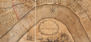
The following beautiful maps show us the looks of some United States cities in the last decades of the 19th century and at the beginning of a new era. Some parts of these cities have stayed unchanged even today, but some neighborhoods are constantly reshaped by the process of modernization.
Cleveland, Ohio


Newton, Massachusetts


Detroit, Michigan


Philadelphia, Pennsylvania


Kansas City, Missouri


The city of New York


Chicago, Illinois


San Francisco, California


New Orleans, Louisiana

