


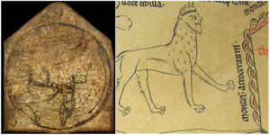
The Hereford Mappa Mundi is an ancient map of the world in the classical “T and O” shape, dating from 1285. For many years, the map hung on a wall of a choir aisle in the Hereford Cathedral in Hereford, England.


In the Middle Ages, great world maps were an English specialty and they were often drawn on walls, cloth, or animal skin. Only the Hereford World Map has survived completely, and it is believed to be the largest medieval map known still to exist.

The map had been laid beneath the floor of Bishop Audley’s Chantry during the troubled times of the Interregnum. In 1855, the map was repaired at the British Museum. During the Second World War, it was moved elsewhere for safe keeping, and in 1964 it was returned to the collection of the Hereford Cathedral.

It was drawn in black ink, with additional red and gold on a single sheet of vellum, it measures 158 cm by 133 cm. It depicts 420 towns, 15 Biblical events, exotic plants and animals, 32 people, classical myths, and wild and strange creatures. The map could only be read by people who spoke Norman French, the language of the literate secular elite.

Because of the pictorial descriptions of the outside world, these kind of maps were also educational. According to Historic UK, they were used for teaching natural history and classical legends and reinforcing religious beliefs.

The “T and O” shape of the map does not imply that its creators believed in a flat Earth. To the ancient Greeks and Romans, the spherical shape of the Earth was already known and the idea was never entirely forgotten even in the Middle ages. It was believed that only the known parts of the Northern Hemisphere were inhabited by human beings, so the circular representation remained adequate.

Today, the map is housed in the famous Hereford Chained Library, the largest surviving chained library in the world.