


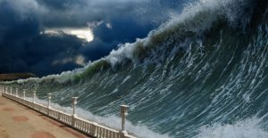
To date, the largest tsunami on record was on July 10, 1958 when a 7.7 magnitude earthquake from the Fairweather fault in southeast Alaska hit, ultimately causing a tsunami with a maximum height of 1,720 feet, or 520 meters! Take a while to try to comprehend a wave that size. In the past, the resulting onrush of water after an earthquake was called a tidal wave by most English speaking countries. Recently, the long-known Asian name of tsunami has been adopted by most countries.
According to wsspc.org, the website for the Western States Seismic Policy Council out of Sacramento, California, the giant wave was caused when a 2400 x 3000 x 300 thick rock (measured in feet) fell from the Lituya Glacier and landed 2,000 feet below in Lituya Bay that feeds into the Gulf of Alaska through a narrow inlet.

When the tsunami hit, there were boats in Lituya Bay where the wave had reduced to about 75-feet-high. All of the passengers on one of the boats were saved but a fishing boat was lost along with two people. Another boat, surprisingly, withstood the wave and was able to sail out of the bay, dodging the thousands of tree trunks that had fallen into the water. Three people lost their lives when the beach of Khantaak Island at the mouth of Yakutat Bay suddenly dropped one hundred feet below sea level.

Small landslides were reported as far away as 155 miles with tsunami waves up to 20 feet tall in Dixon Harbor, Dry Bay, Yakutat Bay, Disenchantment Bay, Skagway, and Inian Island according to Forbes. Even today, 60 years later, the damage done to the edges of the bay is still observable as all vegetation was destroyed by the wave and the land is still recovering.

Local residents, Bill and Vivian Swanson were on a boat in Anchorage Cove when the earthquake hit. A report for The International Journal of the Tsunami Society quoted the couple as saying, “The glacier had risen in the air and moved forward so it was in sight. It must have risen several hundred feet. I don’t mean it was just hanging in the air. It seemed to be solid, but it was jumping and shaking like crazy.”
The couple went on to say that: “Big chunks of ice were falling off the face of it and down into the water… they came off the glacier like a big load of rocks spilling out of a dump truck. That went on for a little while… and then suddenly the glacier dropped back out of sight and there was a big wall of water going over the point. The wave started for us right after that and I was too busy to tell what else was happening up there.”

A 50-foot-high wave came toward Swanson’s boat which rode the crest more than 65 feet above the tops of the spruce trees growing near the entrance of the bay. When the wave passed, the boat fell and began to sink. The couple was able to leave the boat in a skiff and were rescued about two hours later.
Alaska is no stranger to earthquakes. The Pacific and North American tectonic plates meet in this area and along the west coast of Canada and Alaska. The Queen Charlotte and Fairweather faults are part of a long fault system that marks the eastern boundary of the Pacific plate and the western boundary of the North American plate.
Related Video:
https://youtu.be/JYcqI1Drb5A
The two plates move in a horizontal fashion but in different directions. Because of this, Alaska is one of the most seismically active areas of the world. Since 1900, earthquakes have hit Alaska in 1906, 1946, 1957, 1958, 1964, 1965, 1975, 1986, 2002, 2014, 2016, and two in 2018. The 1964 earthquake which hit on March 27th was the most powerful in North American history and the second most powerful in the world at 9.2 magnitude when the Pacific Plate moved northward underneath the North American Plate near the mouth of Prince William Sound.
The quake area included Anchorage and the Aleutian Islands. This writer’s father was on remote military duty in the Aleutians, but his unit was moved to Elmendorf Air Force Base near Anchorage after the earthquake hit. No casualties were reported among his group, and the military set up food stations and water purification units and opened the base for civilians whose homes had been destroyed.
Related Article: Earth has Another Continent Called Zealandia – Only 6% of it is Above Water
Alaskan Earthquakes and tsunamis are a matter of historical record. It is quiet there today. Tomorrow?